Friday and Saturday featured several squall lines (known as QLCS's to weather geeks) across southern Virginia, producing strong straight line winds, plenty of lightning, and lots of rain. Today - Sunday - looks to be much quieter in Mecklenburg county under partly sunny skies, with afternoon temperatures in the mid-80s. A slow moving "cold" front will finally weaken and dissipate, leaving behind continued sticky air but only a few scattered showers and storms today.
The first part of the upcoming work week will bring typical August weather, with highs near 90 degrees and at least some chance of scattered afternoon and evening storms. The main concern later this week will be the remnants of tropical storm Debby, which is lurking off the southwest coast of Florida this morning. Tropical systems are "steered" by the upper air currents (i.e. the jet stream) which will retreat northward toward the Canadian border and leave Debby to its own devices.
The result is illustrated in this National Hurricane Center forecast graphic:

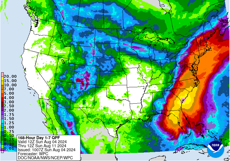
The uncertainty of where and how long these tropical remnants will remain in the area is causing forecasters to go prematurely gray. Suffice it to say that the latter part of this week could be very wet, so be prepared for flood watches and warnings to be posted.
No comments:
Post a Comment