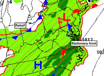
The switch in the weather pattern which brought cooler (i.e. less torrid) temperatures to Mecklenburg county has also ushered in lots of moisture. The heavy rain and storms the past few days have been courtesy of a slowly weakening stationary front that has wobbled back and forth across Virginia. The sogginess will stick around at least through Thursday, but there's relief on the horizon in the form of the next "cold" front which will sweep away the sticky air:
 |
| Forecast surface map at 8 pm Wednesday |
Tomorrow will dawn under cloudy skies with very sticky conditions again. Temperatures will begin the day in the low 70s before climbing to afternoon highs in the low 80s. More rainfall will enhance the sogginess Thursday before that new "cold" front pushes through during the wee hours of Friday morning. The air mass behind this boundary will be noticeably drier, setting the stage for a sunny and less sticky weekend. That's a good thing, right?
No comments:
Post a Comment