Early Sunday morning showers left behind stickiness in the form of 70+ degree dew points. Afternoon temperatures will top out in the mid-80s while the heat index creeps up to the 90º mark. A slow moving cold front will ease its way across Virginia today, firing up late afternoon thunderstorms across Mecklenburg County as it plows into the juicy air.
The combination of the moisture and heat with this boundary's approach led the Storm Prediction Center to blanket Mecklenburg County under a Slight Risk - level 2 of 5 - for severe weather. Potential threats for later today include damaging straight line winds, large hail, and possibly a tornado or two. Folks should stay weather aware late this afternoon, with at least two warning sources kept nearby.
Afternoon highs in the upper 80s accompanied by storms and sticky humidity will continue throughout the first half of the upcoming work week. A midweek cold front looks to scour away some of the humidity, but afternoon temperatures will then rise into the low 90s by the end of the week under mostly sunny skies.
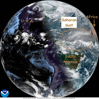
Meanwhile, it's now a full week into the Atlantic hurricane season. However, development of Atlantic Ocean hurricanes is being suppressed by dust flowing westward from the Sahara desert. This morning's visible satellite view illustrates:

No comments:
Post a Comment